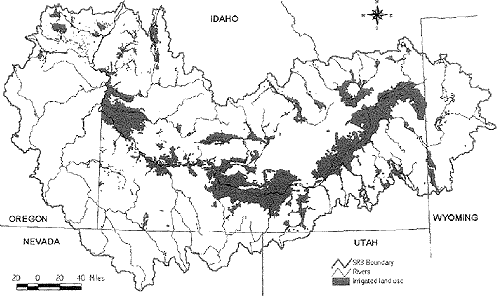
|
Basin
Name
|
HUC
|
Irrigated
Agriculture
|
Non-irrigated
Agriculture
|
Total
Acres
|
Total
Square Miles
|
||
|
Acres
|
Square
Miles
|
Acres
|
Square
Miles
|
||||
| UPPER SNAKE-ROCK� |
17040212
|
820, 645
|
1,282
|
16,325
|
26
|
836,969
|
1,307
|
| AMERICAN FALLS |
17040206
|
692,858
|
1,082
|
182,627
|
285
|
875,485
|
1,368
|
| LAKE WALCOTT |
17040209
|
502,445
|
785
|
214,971
|
336
|
717,417
|
1,121
|
| LOWER BOISE � |
17050114
|
472 ,309
|
738
|
9,230
|
14
|
481,539
|
752
|
| IDAHO FALLS |
17040201
|
426,891
|
667
|
67, 520
|
105
|
494,411
|
772
|
| TETON |
17040204
|
333,784
|
521
|
67,774
|
106
|
401,558
|
627
|
| MIDDLE SNAKE-SUCCOR |
17050103
|
269,442
|
421�
|
856
|
1
|
270,298
|
422
|
| C. J, STRIKE RESERVOIR |
17050101
|
232,809
|
364
|
20,124�
|
31
|
252,933
|
395
|
| LOWER HENRYS |
17040203�
|
182,185�
|
285�
|
182,185
|
285
|
||
| LITTLE WOOD |
17040221
|
170,745
|
267
|
170,745
|
267
|
||
| MEDICINE LODGE |
17040215
|
161,979
|
253
|
161,979
|
253
|
||
| CAMAS |
17040220
|
155,545
|
243
|
150,545
|
243
|
||
| RAFT |
17040210
|
155,020
|
242
|
97,321
|
152
|
252,341
|
394
|
| PORTNEUF |
17040208
|
130,687
|
204
|
234,609
|
367
|
365,296
|
571
|
| BIG WOOD |
17040219
|
129,927
|
203
|
129,927
|
203
|
||
| PAYETTE |
17050122
|
127,203
|
199
|
127,422
|
199
|
||
| BIG LOST |
17040218
|
122,620�
|
192
|
122,620
|
192
|
||
| GOOSE |
17040211
|
114,192
|
178
|
114,192
|
178
|
||
| BLACKFOOT |
17040207
|
104,811
|
164
|
22,630
|
35
|
127,442
|
199
|
| N. FORK� PAYETTE |
17050123
|
100,157
|
157
|
100,755
|
157
|
||
| WEISER |
17050124
|
86,460
|
135
|
86,460
|
135
|
||
| BEAVER-CAMAS |
17040214
|
85, 826
|
134
|
85, 826
|
134
|
||
| BRUNEAU |
17050102
|
53,184
|
99
|
63,184
|
99
|
||
| MIDDLE SNAKE-PAYETTE |
17050115
|
51,294
|
80
|
51,294
|
80
|
||
| UPPER HENRY'S |
17040202
|
45,700
|
71
|
45,700�
|
71
|
||
| SALMON FALLS |
17040213
|
38,878
|
61
|
38,878
|
61
|
||
| UPPER OWYHEE |
17050104
|
35,823
|
56
|
35,823
|
58
|
||
| LITTLE LOST |
17040217
|
34 ,572
|
54
|
34,572
|
54
|
||
| PALISADES��� |
17040104
|
23,051
|
36
|
65,556
|
102
|
88,607
|
138
|
| S. FORK BOISE |
17050113
|
17,907
|
28
|
17,907
|
28
|
||
| JORDAN |
17050106
|
16,995
|
27
|
16,995�
|
27
|
||
| BROWNLEE RESERVOIR |
17050201
|
14,447
|
23
|
14,447
|
23
|
||
| BIRCH |
17040216
|
10,163
|
16
|
10,163
|
16
|
||
| MIDDLE OWYHEE |
17050107
|
7,474
|
12
|
7,474
|
12
|
||
| MIDDLE FORK PAYETTE |
17050121
|
4,839
|
8
|
4,839
|
8
|
||
| SALT |
17040105
|
3,587
|
6
|
3,587
|
6
|
||
| WILLOW |
17040205
|
2,071
|
3
|
117,512
|
184
|
119,643
|
187
|
| S. FORK PAYETTE |
17050120
|
1,047
|
2
|
1,047
|
2
|
||
| S. FORK OWYHEE� |
17050105
|
873
|
1
|
873
|
1
|
||
| E. LITTLE OWYHEE |
17050106
|
654
|
1
|
654
|
1
|
||
| LOWER OWYHEE |
17050110
|
135
|
0
|
135
|
0
|
||
| BOISE-MORES |
17050112
|
74
|
0
|
74
|
0
|
||
| N.& MIDDLE FORK�BOISE |
17050111
|
||||||
|
Total:
|
5,951,908
|
9,298
|
1,117,114
|
1,745
|
7, 069,022
|
11, 043
|
|